
Winter Storm Warnings have been issued for Central Oregon and the Blue Mountain Foothills, while Winter Weather Advisories are in place for the Lower Columbia Basin of Oregon, Blue Mountains, John Day Basin, and Wallowa County.
TRI-CITIES, Wash. - Winter weather is sweeping across the region, bringing snow and cold temperatures. Winter storm warnings and advisories are currently in effect.
In the Yakima Valley, 3 to 4 inches of snow fell overnight, with an advisory in place until 5 a.m. The Lower Columbia Basin, including Richland, reported light snow with up to 2 inches.
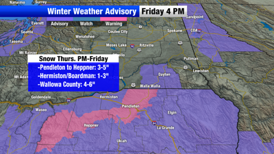
Eastern Oregon is experiencing widespread snow as a shortwave system moves through. Moderate to heavy snow is hitting the Ochoco-John Day Highlands and Blue Mountains. The Blue Mountains, Grande Ronde Valley, and Wallowa County are likely to meet advisory snowfall criteria with high confidence.
In the Blue Mountain Foothills, snowfall totals are uncertain, with 2 to 4 inches expected.
Peak snowfall is expected to continue through 10 a.m., followed by lighter snow as drier air moves in. The winter storm warning for Central Oregon may end early, possibly before 1 p.m., due to dry air aloft. Additional snow showers are possible this afternoon and evening, mainly in the Cascades and eastern mountains.
Looking ahead to the weekend, snow showers are forecasted in the Cascades and eastern mountains on Saturday. Saturday night through Sunday, the northern Blue Mountains could see 5 to 7 inches of snow. Travelers on I-84 should be prepared for light to moderate snow.
The long-term forecast from Monday to Friday indicates abnormally cold temperatures and continued light mountain snow early in the week. A very cold air mass is expected, with temperatures 20°F below normal. Areas like Seneca, Joseph, and Ukiah may experience lows of -5°F or colder. In the Columbia Basin, there is a 90% chance that highs will remain below freezing.
Light mountain snow is anticipated in the Oregon Cascades and Blue Mountains on Monday and Tuesday, with up to 1 inch possible. A new system is expected to bring another round of snow on Wednesday and Thursday, affecting both mountain and lowland areas, though the exact timing remains uncertain.
Residents are advised to prepare for extreme cold and snowfall impacts. For cold weather safety tips, visit [weather.gov/safety/cold] (https://www.weather.gov/safety/cold).
TRI-CITIES:
Friday: P/C, 37/24
Saturday: M/C, Chance AM flurries, 38/23
Sunday: P/S, 39/22
Monday: P/S, 36/16
Tuesday: Sunny, 33/12
Wednesday: M/S, 31/13
Thursday: P/S, Chance Snow, 30/14
Friday: P/S, Chance Snow, 32/17
YAKIMA:
Friday: P/C, 38/21
Saturday: P/S, Chance AM Flurries, 36/20
Sunday: P/S, 35/19
Monday: P/S, 32/9
Tuesday: Sunny, 30/8
Wednesday: M/S, 27/10
Thursday: P/S, Chance Snow, 28/12
Friday: P/S, Chance Snow, 30/14
